This is a special command that is intended to transform the coordinates of the drawing and correlate them with the state coordinate system or any other coordinate system. This feature is convenient when working with maps and georeferencing a building.
How to georeference a drawing?
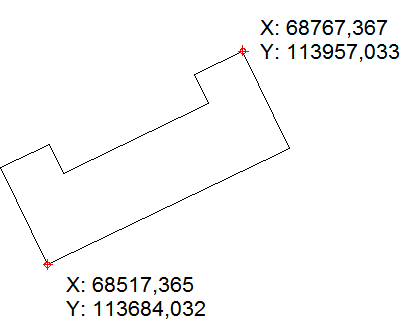
We have a drawing of a building to georeference that is created in the custom coordinate system.

To georeference a drawing and transform the coordinates to the state ones, you need to know the coordinates of two reference points, for example, point 1 (68517.365; 113684.032) and point 2(68767.367; 113957,033). Click the command Set Geo Coordinates on the Advanced tab, the dialog box Geo Coordinates will appear. The first two columns define the current coordinates of the reference points, the columns X2 Easting and X2 Northing should contain state coordinates.

A click on the button Transformation starts the process of replacement of the current coordinates by the specified ones:

Go to ABViewer